


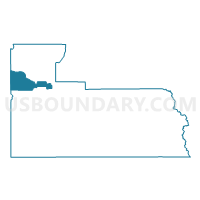
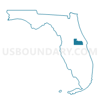
221-Voting District, Orange County, Florida
About
Outline

Summary
| Unique Area Identifier | 557085 |
| Name | 221-Voting District |
| County | Orange County |
| State | Florida |
| Area (square miles) | 31.00 |
| Land Area (square miles) | 5.10 |
| Water Area (square miles) | 25.90 |
| % of Land Area | 16.46 |
| % of Water Area | 83.54 |
| Latitude of the Internal Point | 28.63065180 |
| Longtitude of the Internal Point | -81.55019040 |
Maps

Graphs
Select a template below for downloading or customizing gragh for 221-Voting District, Orange County, Florida


Neighbors
Neighoring Voting District (by Name) Neighboring Voting District on the Map
- 127-Voting District, Orange County, FL
- 130-Voting District, Orange County, FL
- 133-Voting District, Orange County, FL
- 18A-Voting District (Tavares), Lake County, FL
- 213-Voting District, Orange County, FL
- 215-Voting District, Orange County, FL
- 225-Voting District, Orange County, FL
- 226-Voting District, Orange County, FL
- 231-Voting District, Orange County, FL
- 232-Voting District, Orange County, FL
- 234-Voting District, Orange County, FL
- 24-Voting District (Ferndale-Clermont), Lake County, FL
Top 10 Neighboring County Subdivision (by Population) Neighboring County Subdivision on the Map
- Orlando CCD, Orange County, FL (539,261)
- Winter Garden-Ocoee CCD, Orange County, FL (88,573)
- Apopka CCD, Orange County, FL (87,104)
- Clermont CCD, Lake County, FL (78,848)
- Tavares CCD, Lake County, FL (22,707)
Top 10 Neighboring Place (by Population) Neighboring Place on the Map
- Pine Hills CDP, FL (60,076)
- Apopka city, FL (41,542)
- Ocoee city, FL (35,579)
- South Apopka CDP, FL (5,728)
- Clarcona CDP, FL (2,990)
- Paradise Heights CDP, FL (1,215)
Top 10 Neighboring Unified School District (by Population) Neighboring Unified School District on the Map
Top 10 Neighboring State Legislative District Lower Chamber (by Population) Neighboring State Legislative District Lower Chamber on the Map
- State House District 41, FL (252,332)
- State House District 25, FL (179,031)
- State House District 38, FL (162,248)
- State House District 39, FL (132,191)
Top 10 Neighboring State Legislative District Upper Chamber (by Population) Neighboring State Legislative District Upper Chamber on the Map
- State Senate District 20, FL (576,207)
- State Senate District 9, FL (527,435)
- State Senate District 19, FL (477,068)
Top 10 Neighboring 111th Congressional District (by Population) Neighboring 111th Congressional District on the Map
Top 10 Neighboring Census Tract (by Population) Neighboring Census Tract on the Map
- Census Tract 174, Orange County, FL (10,826)
- Census Tract 175.01, Orange County, FL (8,914)
- Census Tract 150.04, Orange County, FL (8,041)
- Census Tract 310, Lake County, FL (7,551)
- Census Tract 175.04, Orange County, FL (7,347)
- Census Tract 151.06, Orange County, FL (7,080)
- Census Tract 123.05, Orange County, FL (6,806)
- Census Tract 123.03, Orange County, FL (6,429)
- Census Tract 313.01, Lake County, FL (5,610)
- Census Tract 151.05, Orange County, FL (3,553)
Top 10 Neighboring 5-Digit ZIP Code Tabulation Area (by Population) Neighboring 5-Digit ZIP Code Tabulation Area on the Map
- 32703, FL (46,207)
- 34787, FL (46,083)
- 32818, FL (43,911)
- 34761, FL (37,500)
- 32810, FL (32,210)
- 32757, FL (23,746)
- 34715, FL (15,455)